Janet and I spent this past weekend paddling the West Branch of the Susquehanna, between Renovo and Lock Haven, PA. It was a great two days with near perfect conditions. This was my third time on this stretch and Janet's first. I choose this section as it had the best scenery with the closest access points along the Susquehanna.
 We had planned to go one weekend in May. When the forecast promised clear skies for May 15 and 16, we decided to pack up and head north. I drove the truck with the canoe mounted on the rack and Janet followed in the car since we would provide our own shuttle.
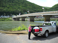
It is a nearly 4-hour drive from our home in Southwest Pennsylvania to Lock Haven. We left at 5:30 Saturday morning, stopping for gas and caffeine along the way. We arrived in Lock Haven around 10, and parked the car in the small lot at the west edge of the retaining wall along the south shore of the river. After a quick stroll on the path built on top of the wall, we climbed back into the truck and drover west along PA Route 120 that follows the river towards Renovo.
Renovo is a small, seen-better-days river town built around a locomotive refurbishment plant. The population in 1900 was four thousand – today, about 1,300 call Renovo home. The railroad business is long gone, so most folks either commute to larger towns downriver or work in the logging or local service industries. Renovo has become tourist-savvy, and hosts an annual Flaming Fall Foliage Festival in October, which multiplies the local population tenfold.
It was quiet here this Mid-May Saturday morning, so we pulled into the large boat access area and unloaded the truck. I slid the canoe into the water and carefully loaded our gear. The water around the ramp looked high and the current further out looked pretty strong.
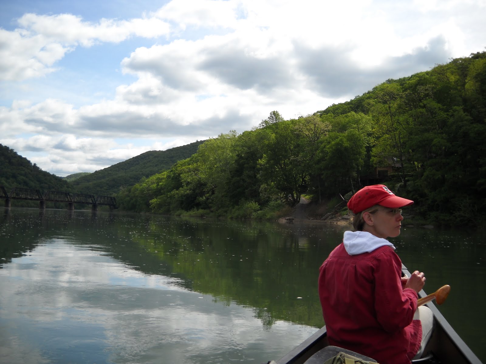
We locked up the truck, climbed into the canoe, and pushed out into the current.
 There’s an interesting transition that happens when you first push off on a downriver trip. You leave mobility, access, convenience, and modernity and replace it with a frail shell filled with all you’ll need to sleep, eat, and shelter for days. It is not without some risk, and safety and even survival is completely in your own hands.
Of course, canoeing a river in the middle of a large east coast state in mid-spring isn’t exactly climbing Everest, but it isn’t a night at the movies, either. There is no cell phone coverage. One lightly traveled road hugs along the river at some spots, and snakes away from it at others. The river is deceptively powerful, with bone-chilling water, fast flows, and strainers along each bank. Elk, bear, badgers, rattlesnakes, and coyotes prowl the woods. Any emergency would be a long way from rescue.
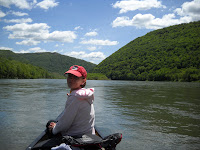
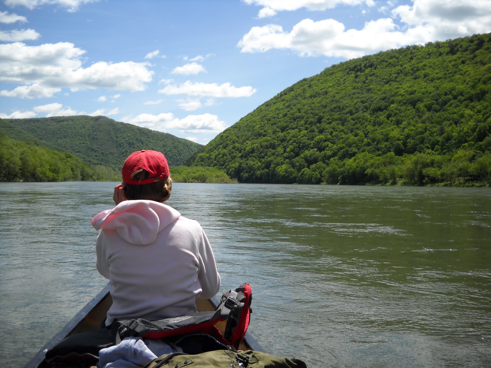
Once Renovo slips behind us, our only companions are a lonely railroad track, geese, ducks, and trees. The river winds its way through and around the high, steep ridges that soar four to five hundred feet above us on both sides, and houses are few and some abandoned.
We originally planned to put in upriver at Keating, but we were running late, and I didn’t want to repeat last year when Nathaniel and I didn't find a place to camp until 8:30 at night, with just enough twilight left to set up camp.
My worries were unfounded, though, as we raced along on the strong current at 5-7 miles per hour. We paddled regularly, but didn’t need to work too hard.
A little over two hours later we passed a mile-long wooded island that splits the river into two fast stretches. We stayed on the left side, where the river is slightly wider. The right side is canoeable, and has more riffles.
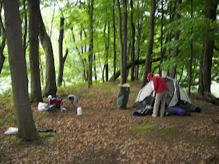
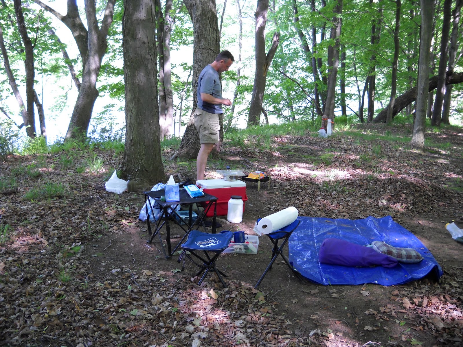
Downstream we found a spot where we could camp. We took our time unloading and setting up. Soon we had a full-blown campsite, with tent, hammock, charcoal stove, table, chairs, and cooler. We took some time to explore until the thick undergrowth blocked our way.
 The West Branch flow is mostly controlled by upstream dams, but this far downstream spring floods can be epic. The trees on this island and all the others we’ve seen all bent facing downstream, mute testimony to the force and height of spring floodwaters. Standing here fifteen feet or so above the racing waters below it’s hard to imagine water surging here through this tranquil, green-coated space.
We returned to our campsite and picked up some firewood – thousands of dried branches carried here by wind and current
We played some board games, read, relaxed, and enjoyed the spring afternoon. The trees blocked most of the sun, and a steady wind whipped down the valley and kept a chill in the air, bit otherwise it was a very pleasant afternoon after a long morning. We enjoyed the antics of some geese that would fly upstream, land on the water, and float downstream honking all the way, and repeat the whole adventure again.
 Around 5 I started the grill and we ate steaks, au gratin potatoes, and peas. The Coleman xponent backpacking stove performed perfectly as always – the charcoal grill was OK, but I’ve lost my touch after using gas so many years. The steaks weren’t perfect, but they were good. We enjoyed dessert of Pepperidge Farm cookies, chocolate, and Hostess Ho-Hos and time together, unspoiled by pressures or demands.
Darkness came a bit early in the tree-covered valley, and by 8:30 we were both beat. I staked out a chem light for midnight bio-break orientation, gathered up the gear for the morning, and we climbed into our sleeping bags.
I read for about 5 minutes and was done. Janet didn’t sleep quite as well – she’s a side-sleeper and the Thermarest pad doesn’t provide adequate padding (I sleep better in a tent outside than I do at home). She was cold at 4 AM so I helped her reset her sleeping bags and pulled the tent fly over a bit more to help conserve heat.
 By 5:30 the morning twilight woke all the birds, so it was time to get moving. I made some hot tea and got breakfast ready. It was chilly – probably in the 40s, and I was glad I packed sweat pants and sweatshirt. We slowly got moving and by 7:30 had everything packed, the canoe loaded up, and we were ready to go.
It’s actually a bit slow going the first morning. You have to figure out where everything goes and you don’t have a routine down. On a multi-day trip the efficiency goes way up and you can be packed and moving in less than an hour. Nevertheless, we bid adieu to our temporary home and pushed out into the current.
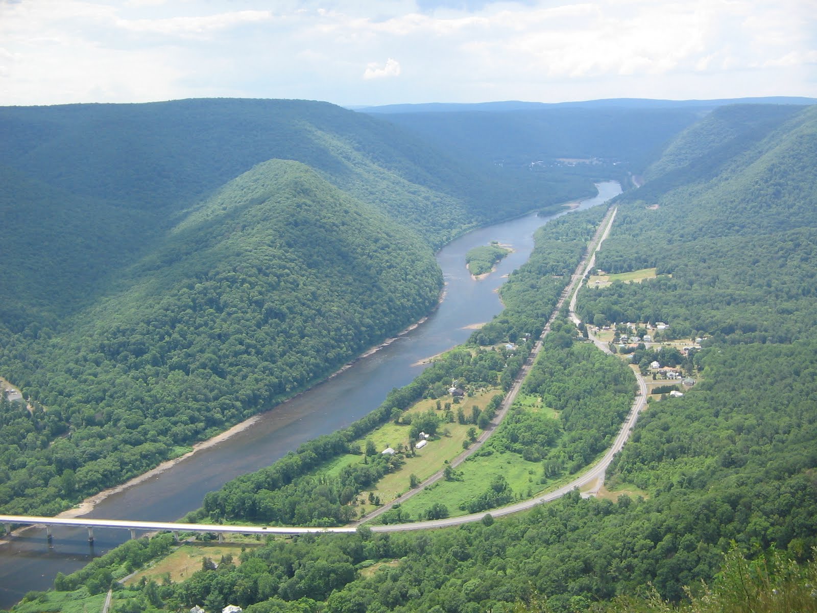
Below the Hyner gorge the river and the surrounding valley widens considerably. Here it’s easy to feel small and insignificant on this big, broad river. Usually the water is clear enough you can see how shallow this river is, despite its breadth. However, with today’s turbid runoff pushing downstream, we saw no bottom.
We raced past now-flooded islands, cutting corners to avoid the wind that started to blow directly against us from time to time. The now-familiar terrain moved slowly past, and we enjoyed the sunshine when peered through some low-lying clouds that swept over from time to time.
There are a few good riffle runs along this stretch, made longer by the high water flow. The shoreline raced by, and the scenery changed quickly. Islands seem to clock two sections of the river – I guided us river left where we zoomed along a narrow channel along the north shore, trees on either side, the way ahead blocked, The water found its way through, with our canoe floating along like a leaf. We pulled into an eddy and climbed onto the spring soft shore for a quick break before the final five miles into Lock haven. Two geese were guarding the island but decided retreat was the better option.
Islands in the Susquehanna are mostly transient, make up of various flotsam that gets deposited during heavier flows. Seedlings spring up during the dry, low-water summer. The saplings are rooted enough yet flexible enough to withstand the next year’s floods. More debris is caught in the web of sticks and twigs and leaves and mud – and the cycle continues.
Some islands come and go annually. Others, such as the island we camped on become established enough to resist all but the most cataclysmic floods. Mature trees grow and eventually the island looks like the surrounding forest.
The West Branch still has several White Pine at least 100 feet tall – likely grown from seedlings that sprouted from behemoths that once covered the hills upstream. Millions of White Pine were harvested to provide masts for sailing ships, raw wood for countless industries, and create fortunes for the lumber kings that built Williamsport and Lock Haven and other river towns in the last half of the nineteenth century. Like those industries and fortunes, the islands are often swept away by unexpected and uncontrollable forces set in motion thousands of miles away.
 Soon we entered the narrow gorge that leads to Lock Haven. We saw more houses – some quite nice, others tiny and overwhelmed by dark trees. Then we passed under the Norfolk-Southern Railway bridge, built at the turn of the last century and coated with a fine patina of rust.
The current continued on, past the point where the flow usually slackens. We entered the last bit of riffles before the retention lake formed by the Jay Street dam – the riffles were long and energetic, and a welcome end to this too-short trip.
Our take-out point was the base of the levee on the south shore. The $85 million dollar project now protects Lock Haven from ravaging floods that had previously swept through. On top of the levee is a very nice walking trail with benches and trash cans every few hundred yards. It’s a great place to see the river and the town, but the grand houses that once were riverfront property now face a grass-covered wall.
We pulled into the swampy area at the base of a ramp that led up to the top of the levee – a good 50 feet above river level. We unloaded the canoe and carried all the gear up to the car on the other side – up the riverside ramp, down the other side and back again.
We drove to Renovo and recovered our truck. We stopped at the local tourist kiosk staffed by a nice volunteer who told us about the foliage festival and the nice canoeing in the fall. We signed the guest book then drove back to Lock Haven.

The canoe was still waiting for us – now looking like a dead fish and no longer an elegant watercraft. I lifted it, placed the thwart across my shoulders and started the long climb to the top of the levee. Back down the other side, one more heave to load it on the rack, and soon we were tied down and departing Lock Haven.
The ride home was long since we were both tired from a busy week and a rushed weekend. But we look forward to another, longer trip sometime soon.
 We had planned to go one weekend in May. When the forecast promised clear skies for May 15 and 16, we decided to pack up and head north. I drove the truck with the canoe mounted on the rack and Janet followed in the car since we would provide our own shuttle.
It is a nearly 4-hour drive from our home in Southwest Pennsylvania to Lock Haven. We left at 5:30 Saturday morning, stopping for gas and caffeine along the way. We arrived in Lock Haven around 10, and parked the car in the small lot at the west edge of the retaining wall along the south shore of the river. After a quick stroll on the path built on top of the wall, we climbed back into the truck and drover west along PA Route 120 that follows the river towards Renovo.
Renovo is a small, seen-better-days river town built around a locomotive refurbishment plant. The population in 1900 was four thousand – today, about 1,300 call Renovo home. The railroad business is long gone, so most folks either commute to larger towns downriver or work in the logging or local service industries. Renovo has become tourist-savvy, and hosts an annual Flaming Fall Foliage Festival in October, which multiplies the local population tenfold.
It was quiet here this Mid-May Saturday morning, so we pulled into the large boat access area and unloaded the truck. I slid the canoe into the water and carefully loaded our gear. The water around the ramp looked high and the current further out looked pretty strong.
We locked up the truck, climbed into the canoe, and pushed out into the current.
 There’s an interesting transition that happens when you first push off on a downriver trip. You leave mobility, access, convenience, and modernity and replace it with a frail shell filled with all you’ll need to sleep, eat, and shelter for days. It is not without some risk, and safety and even survival is completely in your own hands.
Of course, canoeing a river in the middle of a large east coast state in mid-spring isn’t exactly climbing Everest, but it isn’t a night at the movies, either. There is no cell phone coverage. One lightly traveled road hugs along the river at some spots, and snakes away from it at others. The river is deceptively powerful, with bone-chilling water, fast flows, and strainers along each bank. Elk, bear, badgers, rattlesnakes, and coyotes prowl the woods. Any emergency would be a long way from rescue.
Once Renovo slips behind us, our only companions are a lonely railroad track, geese, ducks, and trees. The river winds its way through and around the high, steep ridges that soar four to five hundred feet above us on both sides, and houses are few and some abandoned.
We originally planned to put in upriver at Keating, but we were running late, and I didn’t want to repeat last year when Nathaniel and I didn't find a place to camp until 8:30 at night, with just enough twilight left to set up camp.
My worries were unfounded, though, as we raced along on the strong current at 5-7 miles per hour. We paddled regularly, but didn’t need to work too hard.

A little over two hours later we passed a mile-long wooded island that splits the river into two fast stretches. We stayed on the left side, where the river is slightly wider. The right side is canoeable, and has more riffles.
Downstream we found a spot where we could camp. We took our time unloading and setting up. Soon we had a full-blown campsite, with tent, hammock, charcoal stove, table, chairs, and cooler. We took some time to explore until the thick undergrowth blocked our way.
 The West Branch flow is mostly controlled by upstream dams, but this far downstream spring floods can be epic. The trees on this island and all the others we’ve seen all bent facing downstream, mute testimony to the force and height of spring floodwaters. Standing here fifteen feet or so above the racing waters below it’s hard to imagine water surging here through this tranquil, green-coated space.
We returned to our campsite and picked up some firewood – thousands of dried branches carried here by wind and current
We played some board games, read, relaxed, and enjoyed the spring afternoon. The trees blocked most of the sun, and a steady wind whipped down the valley and kept a chill in the air, bit otherwise it was a very pleasant afternoon after a long morning. We enjoyed the antics of some geese that would fly upstream, land on the water, and float downstream honking all the way, and repeat the whole adventure again.
Darkness came a bit early in the tree-covered valley, and by 8:30 we were both beat. I staked out a chem light for midnight bio-break orientation, gathered up the gear for the morning, and we climbed into our sleeping bags.
I read for about 5 minutes and was done. Janet didn’t sleep quite as well – she’s a side-sleeper and the Thermarest pad doesn’t provide adequate padding (I sleep better in a tent outside than I do at home). She was cold at 4 AM so I helped her reset her sleeping bags and pulled the tent fly over a bit more to help conserve heat.

It’s actually a bit slow going the first morning. You have to figure out where everything goes and you don’t have a routine down. On a multi-day trip the efficiency goes way up and you can be packed and moving in less than an hour. Nevertheless, we bid adieu to our temporary home and pushed out into the current.
Below the Hyner gorge the river and the surrounding valley widens considerably. Here it’s easy to feel small and insignificant on this big, broad river. Usually the water is clear enough you can see how shallow this river is, despite its breadth. However, with today’s turbid runoff pushing downstream, we saw no bottom.
We raced past now-flooded islands, cutting corners to avoid the wind that started to blow directly against us from time to time. The now-familiar terrain moved slowly past, and we enjoyed the sunshine when peered through some low-lying clouds that swept over from time to time.
There are a few good riffle runs along this stretch, made longer by the high water flow. The shoreline raced by, and the scenery changed quickly. Islands seem to clock two sections of the river – I guided us river left where we zoomed along a narrow channel along the north shore, trees on either side, the way ahead blocked, The water found its way through, with our canoe floating along like a leaf. We pulled into an eddy and climbed onto the spring soft shore for a quick break before the final five miles into Lock haven. Two geese were guarding the island but decided retreat was the better option.
Islands in the Susquehanna are mostly transient, make up of various flotsam that gets deposited during heavier flows. Seedlings spring up during the dry, low-water summer. The saplings are rooted enough yet flexible enough to withstand the next year’s floods. More debris is caught in the web of sticks and twigs and leaves and mud – and the cycle continues.
Some islands come and go annually. Others, such as the island we camped on become established enough to resist all but the most cataclysmic floods. Mature trees grow and eventually the island looks like the surrounding forest.
The West Branch still has several White Pine at least 100 feet tall – likely grown from seedlings that sprouted from behemoths that once covered the hills upstream. Millions of White Pine were harvested to provide masts for sailing ships, raw wood for countless industries, and create fortunes for the lumber kings that built Williamsport and Lock Haven and other river towns in the last half of the nineteenth century. Like those industries and fortunes, the islands are often swept away by unexpected and uncontrollable forces set in motion thousands of miles away.
The current continued on, past the point where the flow usually slackens. We entered the last bit of riffles before the retention lake formed by the Jay Street dam – the riffles were long and energetic, and a welcome end to this too-short trip.
Our take-out point was the base of the levee on the south shore. The $85 million dollar project now protects Lock Haven from ravaging floods that had previously swept through. On top of the levee is a very nice walking trail with benches and trash cans every few hundred yards. It’s a great place to see the river and the town, but the grand houses that once were riverfront property now face a grass-covered wall.
We pulled into the swampy area at the base of a ramp that led up to the top of the levee – a good 50 feet above river level. We unloaded the canoe and carried all the gear up to the car on the other side – up the riverside ramp, down the other side and back again.
We drove to Renovo and recovered our truck. We stopped at the local tourist kiosk staffed by a nice volunteer who told us about the foliage festival and the nice canoeing in the fall. We signed the guest book then drove back to Lock Haven.
The canoe was still waiting for us – now looking like a dead fish and no longer an elegant watercraft. I lifted it, placed the thwart across my shoulders and started the long climb to the top of the levee. Back down the other side, one more heave to load it on the rack, and soon we were tied down and departing Lock Haven.
The ride home was long since we were both tired from a busy week and a rushed weekend. But we look forward to another, longer trip sometime soon.